Saturday, October 2, 2010

Segment 17

Sargents Mesa to Colorado Hwy-114


Trailangel Apple's hiker shelter -- just about saved my sanity. Thank you, Apple!


Another sanity-saver -- Razor Creek has been improved by trail crews. There's now a small basin, which usually fills up after every afternoon shower.


Beautiful views a few hundred feet to the right of the trail, around miles 4 to 6.5. Well-worth a little extra exploring!


This segment meanders through the grassy fields of Sergent's Mesa, down through dry and scrubby pine, and up again through wetter woods, over bald mountaintops, and finally winds its way through the aspens and brush of Lujan creek. There are lots of climbs, each followed shortly by lots of steep descents. And there's not much water.

That's the tough bit. When I passed through, I knew I needed about a liter for every four miles, plus another one or two at night. (That's rather a lot, but I'm in crappy shape.) That means finding water for a twelve-mile dry section, plus a dry camp, is tough. I wasn't aware, then, of a rather obvious trick: when you come to a spring, drink. Drink, then drink some more. Sit down beside the creek and polish off two liters. Carrying water in your belly is much easier and more efficient than hauling it on your back.

Since I didn't know that, this segment posed some difficulties. Which makes it all the more a blessing that Apple set up his hiker shelter here, around mile 17.8. Apple's a trailangel, the first of my acquaintance. Trailangels are individuals who have a soft place in their hearts for long trails... and the crazy people who hike them. They drive up to a trailhead with coolers full of snacks and drinks, and sometimes also bring folding chairs (real chairs!) or even fresh foods and a portable stove. One trailangel made omelets all day long for starving thru-hikers. Others, like Apple, choose places where hikers frequently get themselves into trouble and need some R&R -- last year, he said, he was pulling severely dehydrated people off the mountain and hauling them into town, because Razor creek wasn't running at all (if there isn't snow or afternoon thunderstorms, don't trust it!)


The valley between 17.8 and 20.4 is thick with cows -- these ones clustered stupidly near the cattle guard, entirely blocking the way.


Oddly, the sign here says 'road closed.' Duh, really?


About mile 5.0, cairns lead the way off to the right, to an overlook, bench, and great flat campsites.


Suggested updates to the guidebook:

0.0
The trail heads slightly up, then gradually down into more interesting terrain. There are a great many mushrooms throughout this area.

1.0
It's tough to tell that this knob has been burned, now. But there aren't any intersecting trails -- just follow the road. You can't get lost.

2.3
About when you start thinking you must surely have gone too far, you'll find this turnoff to the right. It's now clearly signposted, and the route well-trod. It's hard to miss.

~5.0
Somewhere around here, just where the thick forest starts to thin out, a few half-hidden cairns lead the way to the right. There are fantastic, flat spaces here for camping, and a very lovely overlook with a bench. No water, though.

6.9
The trail for a half-mile radius around the baldy lake turnoff is thick with mosquitoes, as is Baldy lake. If you've had rain, if there are puddles on the trail, you're almost certainly safe to skip baldy lake and go ahead to Razor creek instead.

10.5
Razor creek doesn't quite deserve it's 'half-cup-full' designation in the databook. It drains a very small valley, so if there hasn't been rain in the past day or two, you'll be out of luck. The creek has been improved, however -- there's a small basin built of stones just beside the road.

10.8
There's a fantastic camping spot here, just before the trail leaves the creekbed and heads left.

11.5, 12.4, 12.8
Trails break off from the CT. They are well-signposted.

17.8
Join up with a dirt road. This is where Apple, a trailangel, had set up shop.

19.2
Lujan creek was flowing very well when I passed (though it was an excellent water year.) If you've been seeing plenty of rain and Lujan creek is full at this point, then don't worry too much about water -- Pine and Archuleta creeks, up ahead, will almost certainly be flowing. Past this point, BTW, it's hard to quickly get out of sight of passing vehicles for about the next 3 miles, so if you need to pee....

20.4
The tarmac here looks alien after so long on the trail! Turn right and head down the road about a mile or so. Keep an eye open to your left for a very wide, deep parking area.

The elevation listing here is not correct -- the elevation at mile 10 should read 11200, not 12200. Big difference. Also, I *believe* the elevations of the minor summits at 14.6 and 15.5 should be around 11250 and 10700. However, it's possible that my cheap little altimeter had a malfunction. I certainly felt like *I* was having one -- all those darned false summits, dips and climbs!

---> Onward, to segment 18!

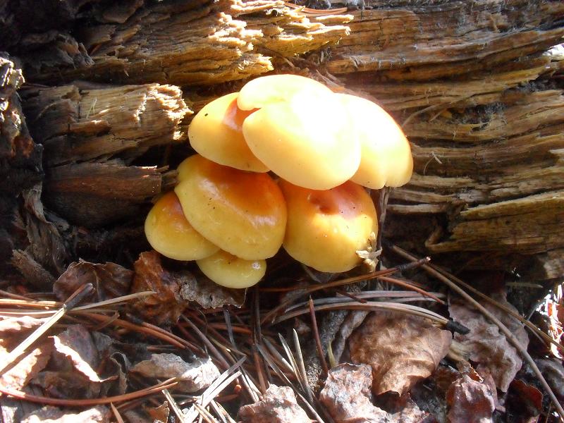
Mushrooms of the CT!


Making mushroom jerky! Slices dried well on hot rocks around the fire.


A Hawkwing mushroom -- evidently delicious if sauteed a while, otherwise sometimes bitter.


Possibly an inky cap -- delicious when young, but causes adverse reactions when consumed with alcohol.


2010 was a fantastic year for mushroom hunters throughout Colorado. There was plenty of rainfall, and temperatures stayed generally mild. Except for in the dryer regions near Denver, mushrooms were everywhere along the trail -- sometimes sprouting inches from the path... or right in the middle of it! And after you've been walking for four or five days without fresh foods, some fungi can look pretty darned tempting. There's one that looks like creme brulee, others that have a fantastic sweet scent, and up in high alpine meadows the ground is littered with what looks like loaves of bread. Not only are mushrooms nutritious, but they're also mainly water. This was a great water year, but there were still places where I'd have gladly snacked on a high-water food source -- one I didn't have to carry -- in order to make my water bottles stretch a little further.

The only thing is... how do you keep from ending up in the hospital, or worse? Quite a conundrum.

Fortunately, I met Katrina along the trail. She runs the Turtle Lake Refuge wild foods restaurant, in Durango. She was walking from Durango to Telluride in order to be an instructor at the wild mushroom festival there. She recommended two varieties that are fool-proof to identify -- one of them is probably the best mushroom I've ever tasted, wild or not. I ate pounds of it, made jerky of it, put it in my soup every evening. I present to you:


The King Bolete.

Scattered at high elevations like loaves of bread, these monsters can be bigger than footballs or small as a golf ball. They are very, very common, and are easy to identify due to four distinctive features: First, they have no gills, but rather white or yellow sponge on the underside. In very young ones, the sponge is white and so fine-grained you have to look closely to see the pores. This is the most important ID characteristic. Second, they have a thick, squat stem. Third, they are a pretty tan/brown/rust on top, resembling a loaf of bread or a dinner roll. Four, the flesh is white, pleasantly aromatic, and crisp. They usually grow over 10,000 feet -- the first half of segment 27, for example, has thousands of kings scattered *everywhere.*


A huge bolete.

There are a number of related bolete species -- so don't go eating just anything with sponge instead of gills -- but in Colorado, only a couple very rare ones are toxic. They don't look like the kings, have bright orange or red undersides, and the flesh isn't white but rather stains blue when bruised. They may smell like carrion. If you can manage to gag one down, it'll make you darned sick for a while. If you're not certain, don't eat it.

Other common boletes are edible, they just might not taste quite like the king. The queen bolete is rarer than the king but has even better flavor; the queen is a darker purple/tan on top but otherwise identical. Slippery Jacks grow at lower elevations, have a thin stem, usually have a slippery/slimy film on top which should be peeled off, and are pretty bland, verging on insipid.


An unidentified bolete of some sort; not poisonous, but probably not tasty.

Kings and queens, however, are fantastic raw or lightly cooked. If you can figure out how to saute them so much of their liquid evaporates, using the cooking gear available to you on the trail, they're even better. The flavor is nutty, earthy, a little like vanilla. Try oriental ramen with a tin of kippered herring fillets and a whole lotta kings. Or add them to any stroganoff or cheese dish. Scrumptious!


Cheesy tuna with lightly cooked king boletes -- tasty and filling!

One caveat: boletes are much beloved by pretty much the whole animal kingdom. You'll often find places where bears or deer have eaten every king in a field, leaving only bits of the stem behind. Sadly, insects also like them. Especially at lower elevations or in wet places, older boletes may have grubs or worms inside. You can either trim off the bad parts on big mushrooms, or only collect the smaller mushrooms, which the bugs haven't found yet.


The underside of a king bolete.


The Giant Puffball

In the fields near the end of segment 24, there were dozens of these large white fungi, most as big as soccer balls. When they're that big, puffballs look like no other mushroom on earth -- you can't make a mistake with identification. They're best picked before the top has split open, when the flesh inside is white and firm but never hard. Old mushrooms are pithy and have a mealy texture. Shades of yellow or blue inside or a bad smell mean that the mushroom is really old; if you somehow gag it down, it will cause upset stomach.

You can eat the nice firm puffballs raw or cooked. If there's a thin, leathery outer layer, you should peel it off, because it may taste strange. Puffballs are best when cut into steaks and browned in butter, or breaded and fried, or paired with strong cheeses -- they have a strong, earthy, mushroomy flavor. You can toast them on a stick over a campfire like marshmallows, but they're also alright just cubed and simmered in soup.

Small or immature puffballs, ones around golf-ball size or smaller, are a little more complicated. There are many different varieties, some with spikes, some with studs or lumps, some crackly and pearl-shiny, some tan and pear-shaped on the outside (white inside.) All are edible, though some are very bland. The problem is, you need to sit down with every one you collect and a sharp knife, and slice it down from top to bottom. This is because small or young puffballs resemble baby aminitas, many of which will kill you dead. Which is something you probably do not want.


A cluster of baby puffballs.

If you cut your baby puffball open (from top to bottom, remember) and find that it has a design inside -- actually the developing cap and gills of another mushroom species -- it is not a puffball. It may be poisonous, it may be delicious, even experienced mushroom hunters can't tell which. Throw it away, and wipe off your knife. If you cut open your puffball and find only pure, white, snowy insides, then it's a puffball. (Deep-fried meatless meatballs, anyone?)


-----


Russula #1


Russula #2


Russulas, like the three above samples, grew thickly in the dry pine woods at all elevations. They often emerge still covered with dirt and pine needles. The white one, a short stemmed russula, is edible but very bland. The red one with the white stem has a powerfully peppery taste and can make you sick. Another very common kind -- a darker dusky purple topped fungi sometimes with a slightly rose-blushed stem -- was the delicious shrimp mushroom, which tastes sort of like its name. Wish I'd known what I was passing up!

-----


This little guy looked perfect and tempting -- but broke when I tried to examine it. The pic isn't a good one, but it's possible this was a Destroying Angel. It's evidently a good idea to avoid all pale, veiled fungi until you're a lot better at identifying 'shrooms than I am.

-----


View of bottom


View of top.


Another specimen. This large white mushroom started showing up all over the place, towards the end of the hike. Sometimes they were dinner-plate sized. It may be either a leucopaxillus or a clitocybe -- the two families have both tasty and toxic members.

-----


Unknown!


Unidentified... but looks delicious....


Also unidentified.


Still not sure what these guys are.

-----


I believe this is a trophy cluster of oysters -- I should have picked some and turned them over to check out the underside.

-----


This might be a cluster of edible-but-bland velvet foot, cousin to the enoki found in sushi... I should have checked out the undersides!

-----


Some kind of a Pholiota -- smelled like pizza, but not usually eaten as it makes some people sick.

-----


A club or strap coral mushroom cluster.


Another club coral mushroom, possibly the 'flat-topped' variety, which is sweet enough to serve for dessert!

-----


Fly Aminita #1


Fly aminita #2 -- older mushrooms tend to fade to yellow or orange, but still have the spots over the top. These are toxic -- but also famous for being intoxicating.

-----


A whole clearing full of apricot-scented mushrooms (scrumptious, juicy chanterelles.) Oh, if only I'd known then what I know now!

-----


My only real regret about hiking the CT is that I didn't bring a mushroom ID guide. I cannot adequately describe how plentiful and perfect the mushrooms were -- and a big plate of oyster 'shrooms for dinner appetizers would have been fantastically welcome... especially on those segments where I, erm, miscalculated how much food I needed. A guide would have been well worth the extra six ounces, and I would have been much healthier and far more entertained on the trail. Check out the pocket guides by David Arora, who is very strange, but knows his stuff.

Thursday, September 30, 2010

Segment 16

Marshall Pass to Sargent's Mesa


The pond around 1.5.


Hail on its way, around mile 5.3.


The first half of this segment is a popular bike ride -- people take a shuttle up from Poncha springs and zip up the trail. They turn off at 4.1, though, so then you'll have the road to yourself. For a while. Around mile 12, you'll almost certainly be joined by cows... or by their pies at the very least.

Near the very end of this segment, at Sargent's Mesa, you may be able to spot the Soldier's Stone. It's a tall granite memorial, inscribed with poignant and profound quotes about war, most in languages other than English. Its erection was meant to honor the sacrifice of soldiers, on all sides of conflict... and to comment on the anguish of war.

I do not, alas, know exactly where it can be found -- the Forest Service intentionally does not publicize the location. It is, however, just barely visible from the trail. The memorial is surrounded by a low wall of local stone, to prevent cattle damage, but that means it blends into the landscape. There are a few pictures of the place, available here.


Once out of Tank Seven drainage, the terrain on Sergent's Mesa is rolling, short-cropped grassy fields spotted with clumps and stands of thick old pine.


Cows on Sergent's mesa.


Guidebook update suggestions:

0.1
Keep a careful eye out here for CT triangle markers. You will make about three or so turns at possibly confusing intersections over the next 0.2 m. There is Verizon cellphone service from a hill overlooking Marshall Pass.

1.5
To the left was a very small pond, mostly hidden among the plants. I spotted it about two days after the last heavy rainfall. Pic below. Probably not very reliable.

4.3
I couldn't see the spring that is supposed to be near the bottom of the slope, off the trail... but there was so much water in other places, there was no need to go hunting it.

4.7
For example, here. About twelve hours after moderate rain, there were two streams crossing the trail through this section. The trail was also very, very muddy -- and very slow going.

5.5
As I headed up the switchbacks at this small secondary peak, there were signs of a motorcycle crash -- half a visor at one switchback, then later a wickedly ripped kneepad, then a piece of fender... careful if you're biking. Evidently the trail can get slippery here.

6.5
Descend into a very thick, young forest which sometimes seems endless. Off to the right, though, you will soon glimpse vistas and valleys -- welcome reminder that you're standing atop the Continental Divide.

8.8
Campsite to your left.

8.9
This pipeline swath is now very hard to spot, and you do not actually 'join' it for any appreciable length. Basically the only indication that you're crossing the pipeline is a stand of very small pines, and once you pass them, if you look back over your right shoulder, you might spot some circular orange warning signs.

11.0
Tank 7 trail joins to your left; stay straight.

11.6
Cross creek. There should be a cleaner tributary just up ahead if you don't want to drink cow-flavored water.

11.7
This seems to be the best place to fill up. However, the rest of this valley (about 2 more miles) may have several flowing springs, if there has been rain the last few days. But there's also a lot of cow poop laying around. Camping is poor for the next 4 miles due to cows.

15.0
An odd little fenced area to your left protects a small marshy region, and there may be some water there.


The elevation profile is mainly correct, but remember, even though a section might look smooth, you will be climbing and descending dozens of rocky little 50-foot rocky hills. Don't worry too much if the profile says 'flat' and your feet say it's anything but.

----> Onward, to segment 17!

Segment 15

US-50 to Marshall Pass


The views are endless at mile 8.6.


Atop the Continental Divide.


The trek between Salida and Creede, some 95 miles, is the longest stretch on the CT between resupply, but that isn't nearly as scary as it sounds. It took me nine nights, and I went pretty darned slow. While there are a couple long-climb areas, for the most part the trail is in good shape and in some places it is quite flat, so you can make good time.

You'll have to, if you bought Uncle Ben's Garlic and Olive Oil Flavored Wild and Brown Rice. Really. I don't know what kind of arcane chemical they put in that stuff, but whatever it is, it seeps through ziplock baggies. So if you repackage your Uncle Ben's Garlic and Olive Oil Flavored Wild and Brown Rice into a plastic baggie, and you package most of your other food in ziplock bags, you will soon have a great deal of Uncle Ben's Roasted Garlic and Olive Oil Wild and Brown Rice-flavored foodstuffs.

For example: Uncle Ben's Roasted Garlic and Olive Oil Flavored Wild and Brown Rice-flavored dried cranberries, Uncle Ben's Roasted Garlic and Olive Oil Wild and Brown Rice-flavored marshmallows, Uncle Ben's Roasted Garlic and Olive Oil Wild and Brown Rice-flavored drink mixes, Uncle Ben's Roasted Garlic and Olive Oil Wild and Brown Rice-flavored cheese.... yeah.

I've never come across a foodstuff that so laughs at the laws of physics, that can spread indefinitely throughout the contents of a pack without ever losing its potency. Given enough time, I feel that Uncle Ben's Roasted Garlic and Olive Oil Wild and Brown Rice may spread across the entire planet, tainting whole fields of grain and herds of animals. Who can stop this menace?

Not me. I'm too busy scrubbing out my pack. Thanks a lot, Uncle Ben. :/


Garlic-flavored dessert. Why oh why, Uncle Ben?


Guidebook update suggestions:

0.1
After you leave US-50, head downhill towards the Fooses creek bridge. Keep your eyes open for the next half mile, as new housing developments are going in, and roads split off to the right and left. The CT is indicated by white triangle markers and the occasional sign.

0.8
Fishermen here were having no luck.

2.7
The only marker at this road fork may say "South Fooses Creek TH" but nothing about the CT -- go left anyway.

2.8
Cross a bridge, and leave the road for peaceful singletrack at long last.

5.0
This 'campsite' is practically straddling the trail. If you can even get another mile or three further up, there are much better places to camp nearer the treeline.

5.5-7.5
Frequent x-ing of small rivulets and seeps, some of which were muddy.

8.5
This section is indeed among the steepest of the entire CT, as the guidebook warns. But don't worry about it too much -- it's very short, and if you climbed up the ten-mile range before Copper Mountain, you've handled steeper spots. Trekking poles are useful.

8.6
GO LEFT. If you take a quick glance at the signs (and mix up 'Monarch' and 'Marshall') or just glance briefly at your compass, it is possible to wander off in the wrong direction, thereby heading towards Canada. Believe me. GO LEFT. Oh, and also there is no cellphone service here.

10.6
This spring was running fine, and there was water trickling through culverts under the trail in a couple places beforehand. The spring will be along the uphill slope to your left. Tasty water!

12.6
Though not mentioned in the databook, there is a lovely (and probably moderately reliable) stream here, with a good campsite just before.

12.9
Ruins of an old cabin sit nearly on the trail, to your right.

13.0
The second piped spring spills across the road. Terrific, sweet water.

13.5
If you somehow forgot to fill your water bottles, there is an irrigation ditch here, then a swampy/watery section, which may have water.

14.3
The toilet is directly across the road. Once you have finished inspecting it, head uphill, west, towards the prominent pass.


The elevation profile for this segment is roughly correct.
----> Onward, to segment 16!

Thursday, September 23, 2010

Segment 14

Chalk Creek Trailhead to US-50


The trail, carefully maintained, near mile 13.


Seems like a whole lot happened during this segment. I obtained a trailname of sorts -- 'Lucky' -- (lucky for the fish, ha ha!) and fought off a mudslide, talked botany with Dr Jeff and started a fire in a puddle on sodden wood (using half a box of matches, mind.) I was divebombed repeatedly by a young hawk, who didn't even want the beef jerky I was trying to feed it. I met Karl and Max, who'd been hiking since the mexican boarder, and were correspondingly a little strange; I stuffed myself on wild raspberries and tried to teach a raven to say 'who's there!' and 'oh no, a bear! Run!' Because other hikers would surely be amused by such utterances floating through the spooky, creaking woods. Wouldn't you be entertained? Of course you would. The raven was already making a range of burbles and toks, anyway -- clearly it enjoyed expanding its vocabulary. I was just being helpful.

Naturally, I got my karma back that very night. The sun had just gone down, and I'd crawled into my tent for the night. I was just falling asleep... when I was jolted by a freakish scream. It was long, a harsh and high-pitched 'NEEEOWGH!' that seemed to crawl right up the spine. There was a pause, maybe ten seconds. Then the sound came again. The noise, in fact, was most similar to a horse screaming... or a woman screaming.

A woman screaming. I'd heard people talk about that sound.

Cougar.

Suddenly, I really, really, really needed to get out and pee.

Crudmuffins. Cooking pot in one hand, I bolted from my tent -- possibly levitating as I did -- and seized a trekking pole. Clashing one 'weapon' into the other, I screamed back. "Go away! Go bother someone else! Eat me and I'll clog your arteries bigtime!" I found a rock on the ground via the expediency of smacking it with my bare toes, and began bludgeoning it with my cooking pot, setting up a clanging that must have carried for miles.

There was a silence, longer this time. Then the scream came again, perhaps a little more distant.

Clutching my weapons, I scuttled to the embers of my cookfire and built it up as best I could. Being unwilling to venture beyond the circle of light for firewood, I broke up and burned the logs that had been placed around the campsite as chairs. Apologies in advance to those wishing to camp before Salida -- there's no longer much to sit on, around mile 18. Sorry.

It took a while to build my bonfire -- with every repeated scream from the thick forest, I'd howl back, whack the rock some more. My cooking pot never did look quite... normal, after that night. At last, when the flames were leaping four feet in the air, the screaming started to move off. But it did so very, very rapidly. Between one scream and the next, the sound's source moved entirely down the valley, and without any sound of an earthbound animal crashing through the underbrush.

Hm. Very fast moving... unfazed by my threats and my fire.... what could it have been! I'd have to find out, in Salida.

Now, Salida itself is a pretty great town to spend a couple days, especially after sitting awake and shivering in fear for almost the entire night before. Only one hotel's number is listed in the CT guidebook -- the Super 8. Hikers whom I passed rated it quite highly; a room should set you back around 50 bucks. The owners will drop you off at the trail in the morning for about fifteen bucks, too. They will *absolutely not* pick you up from the trailhead. The Super 8 is located a mile from all the shops you'll need to visit, in kind of a tired area full of Jiffy-lubes and Burger Kings and the mental health center.

At half that price, you can also get a dorm bed, right in the middle of the downtown, at the Simple Lodge and Hostel. They have free wifi, a communal kitchen, free stuff to make waffles in the morning, and plenty of people with whom to speak about the trail conditions ahead. Call in advance to book a bed if you'll be arriving on a weekend. I ended up staying at the Simple Lodge, largely by accident, since that's where my hitch dropped me off. Also, it turns out that the awesome proprietor, Jon, is friends with a couple of Peace Corps volunteers who trained me in Malawi. Small world!

Jon will drop you off at the trail for $15, and *possibly* can pick you up, if absolutely necessary -- however, he cautions that hitches into town are really easy to get and, as the traffic is mainly local, this part of I50 is also a very safe place to hitch. Flagging a ride into town took me about eight minutes, and my lift was an organic foods grower and seller, who gave me the lowdown on local places to shop and left me with some fantastic smoked trout. The Simple Lodge is located on 1st street, between D and E streets. The lodge is the cute little old house with a bench and grass and sunflowers, next to a bikeshop and daycare, across the street from the place that sells weird metal sculptures. If Jon isn't there to give you the code, you can stick your pack around back (down the narrow alley to your right.) The number is 719-650-7381.

I met a couple of old friends there -- they'd been hiking faster than me, but decided to stay some extra days, as they found the hostel a pretty awesome place for R&R. And they really needed some: they ate bad mexican food in Buena Vista and had been, erm, jet propelled -- and not in a good way -- for the last forty-three miles or so. That's enough to take the wind out of anyone's sails. And force them to buy new pants, too.

The restaurants in Salida are fantastic; definitely try Aminca's Pizza Parlor's calzones. One will definitely fill even a starving hiker's belly. There are far too many great places at which to eat -- I was staggering between some of them when something rather interesting happened. I was just headed down the street, affectionately patting my food-baby, when a commotion from behind made me turn. "What about *that* girl!" screamed a waif of a girl, dressed in black, pointing wildly as she slid into a beat-up little hatchback. "Is *she* fat!? Huh!?" I looked behind. Nope, the little goth was definitely gesticulating at me.

The young man in the driver's seat said nothing. But the back of his head seemed to be shrinking, as if he were sliding lower and lower into his seat. "Well?! Answer me! Do you think *she's* fa..."

"I prefer 'Rubanesque'," I called back, waving cheerfully. After living in Malawi, and hearing my weight commented on daily ("Oh! You are looking very fat today, Madam!") I don't think I'll ever be capable of taking offense in the subject again. And, heck, I was even a little pleased that there might now be some question as to whether the appellation applied to me. But the young man declined to engage in conversation -- indeed, the back of his head vanished behind the headrest as he gunned whatever passed for his vehicle's motor and peeled away. The waif in black, apparently oblivious, was still screaming at him from the passenger seat.

Interesting couple. Hope everything works out for them.

Perhaps the awesomest thing about Salida is the library, three blocks SW of the hostel. It's a standard small-town library, with lots of fun novels if you need to while away an afternoon. But it also has about ten internet terminals, free of charge. Just sign up at the front desk. Once online, you can look things up -- for example, a listing of the kinds of animals which scream in a terrifying manner, and also can move very fast and are not too afraid of humans.

Turns out, not all owls say 'who.' Weird, huh?


A cut and replanted section, near mile 17.6.


Fantastic, but dry, campsites around the big clearing at mile 18.5.


The terrifying (if you're a mouse or a hiker) Western Screech Owl.


Guidebook update suggestions:

0.0
After crossing the big bridge, make sure to pick up water. The ravine ahead did hold water, but Eddy creek was not running -- not even after a heavy rain.

0.1
Immediately after Chalk Creek, the trail dissolves into spaghetti. Watch carefully for markers, and keep to the most well-worn path. If you're still uncertain about a juncture, look for the trail with the most bootprints and trekking-pole pockmarks, as other trails may be mainly used by horses.

0.9
This ravine had plenty of water, but you had to scramble down a steep embankment to get to it.

3.9
This is a big, well-used road with big, well-used campsites.

9.4
The trail touches, but doesn't cross, the wide switchback of FS road 275. If you're walking near sunset, you might mistake this for a lovely, hard-packed clearing. It isn't. Don't camp here.

10.0
Don't camp here, either. Oh, it looks like a pleasant enough spot, carved into the hillside just above Sand Creek. Someone had even cut and split lots of aspen logs for a fire. Thing is, if you get moderate or heavy rain, the entire campsite (but especially the spot you might logically put a tent) becomes a swift-flowing stream several inches deep in places. You'll spend the rest of the night and all the next morning drying off your erstwhile waterbed. Many other meadows, especially around mile 12-13, are much, much nicer. Trust me on this one.

12.4, 12.8, 14.5, 15
The day after heavy rain, small streams trickled across the trail in many places.

16
Look for wild raspberries here, on the steep part of the climb up to the wooded saddle. There were several large patches of sun-warmed, juice dripping fruit -- I sat down and ate for a good half-hour.

18
There are no more camp chairs here. My bad.

~18.5(?)
After crossing a small dirt road, you'll find a large marshy clearing up ahead, surrounded by some fantastic campsites. Some of them are posted 'no fires', due to heavy use, though I saw no one in the area. Though it is not obvious, the CT heads around the *right* side of the clearing, keeping just within the forest. Don't follow the road.

19
Watch out for angry hawks. Also, owls.

The elevation profile for this segment is roughly correct.

---> Onward, to segment 15!

Segment 13

North Cottonwood Creek Road to Chalk Creek Trail Head


The view near Bald Mountain.


Wildflowers near Silver Prince creek


Wildflower-covered slopes near Silver Prince Creek.


Me 'n the flowers. The CT isn't really strenuous -- if you take your time, pretty much anybody can complete it.


This is the segment in which I came closest to spotting a bear. Only about a third of hikers on the CT -- to judge by my informal questionnaire -- ever actually see a bear over the course of their adventure, and nobody that I asked has actually been bothered by one, whether food is kept in the tent or not. But 'round about mile 8.5, where I was walking early in the morning, a dayhiker headed the other way said they'd seen one not ten minutes back. The man's yappy yorkshire terrier, straining at its leash, had terrified the bear and sent it fleeing.

Many car-campers along the trail asked me if I wasn't frightened of the wildlife. Well, no, not exactly. For one thing, grizzlies are vanishingly rare in the area, and aren't habituated to humans, anyway. For another, with my big pack and wildly-flailing walking sticks, I'm roughly troll-sized -- and not the cute kind of troll, either. After a week on the trail, most hikers probably smell rather like a troll, too. Cows look on hikers with a slow, bovine anxiety. The dogs I met nervously tried to herd their humans away, or took a stand to defend their families. Squirrels chattered their alarm. Everything else out there -- with the possible exception of birds, such as one angry young hawk near Salida who keeps trying to divebomb passing hikers -- is intimidated by humans.

Non-primate animals have a harder time of it. Twice along the CT, I found a thoroughly gnawed young deer leg lying in the trail. Just a leg. That's it; nothing else. What kind of critter kills something and then just leaves the legs off? And right in the middle of where I'm walking, too. Sheesh.


Why, oh why?

The end of this segment is very close to the half-way point, and if you haven't had a shower since Breckenridge, it's tempting to splurge on a fancy hotel room here. The Princeton Hot Springs Hotel, however, is often booked very much in advance. Also, other hikers have reported that if you arrive at the front desk looking like, well, someone who hasn't had a shower since Breckenridge, the hotel staff may claim falsely not to have rooms available. The is a Fancy Place. Or something.

Instead, I used their courtesy phone to call Cheri, who runs the Roca de Tiza, a bed and breakfast just up the road. Her rates are roughly comparable to the hotel's ($140), but you get an enormous breakfast, free pickup and dropoff to a point of your choosing (if you'd like to skip the long walk along the busy road, for example), laundry, and all the bathing supplies of which you've been dreaming. No tiny hotel shampoos here, but rather a selection of oils and creams and soaps and bubblebaths and conditioners -- it's a wonder I ever left the bathtub. Roca de Tiza is some distance from the nearest hotsprings, however, it does have an outdoor jetted hottub overlooking the river, as well as an enormous deck, swinging chairs, hummingbirds aplenty, a book exchange, deeply comfortable couches, a pool table, a fire pit, deer browsing in the back yard in the morning, gorgeous architecture... and Cheri, who is pretty darned awesome, not least because she built the all-wood house herself. She's also fantastically accommodating, will let you use her landline, and even permit you to check in early if she can, so that you can run and lock yourself in the bathroom and hug yourself with happiness. If you're going to treat yourself, definitely try Roca de Tiza -- they do have only four rooms, though, so call ahead. Cheri: 719-395-8034


A bridge over one of Maxwell Creek's many streamlets. I'm consistently impressed by the volunteer-built bridges along this trail. They are, quite frankly, a marvel. In Malawian villages, footbridges used daily by hundreds or thousands aren't built nearly this well. I'm still not sure why; there are plenty of trees of this size in most areas, and everyone has the tools needed for a bridge like this: a nail or two and a really big machete. Strange.


My pack takes a breather near Dry Creek.


The road you follow down into Princeton Springs. Last chance for cell phone service.


The Roca de Tiza, exterior.


The Roca de Tiza, bar and breakfast table.


Databook update suggestions:

2.5
This is a beautiful little valley, and would make a fantastic place to camp. The final climb is very steep and nasty in stormy weather.

4.8
Note that this water source is hidden down a gully to your right, and is hard to find. Don't necessarily count on getting water here.

6.0
This bit looks (from the elevation profile) like a very, very steep descent -- but switchbacks have now been added, and it is presently a very pleasant section of trail. It is exposed in case of rain, though.

8.0
A trail heads steeply down to the left, to the edge of a beaver lake. It had fish and possible campsites. Stay high for the CT.

11.6
It's actually really hard to tell where this saddle is located along the trail. Don't worry, there aren't any intersecting trails, so you really can't get too lost.

12.8
There was a tiny little stream running across the trail here, a couple days after heavy rain. Silver Prince Cr is up ahead.

14.0
Maxwell creek was actually a series of about five small babbling streams, all winding their way down a small wooded valley.

15.9
A nice sized creek, but shallow, so probably no fish. Last water for 4.5 miles.

17
The trail abruptly disgorges you onto an enormous dirt road. No camping past this point -- not that you'd probably want to.

19.5
The view coming into town is fantastic. Follow the road as it heads downhill, bends left, ends in a T intersection. There is no cellphone reception in this valley.

20.3
The CT hits a T-intersection and turns right, heading down the paved road for a darned long ways. The main hot springs hotel is directly ahead at this intersection -- you'll need reservations in advance, especially friday, saturday, and sunday. The convenience store is superb for restocking; it's across the street and 100yds to your left, sharing the parking lot with the main hotel. Make sure to check in the upright refrigerated cases directly ahead -- mmm, tasty cheese!

Elevation profile is mainly correct.

----> Onward, to segment 14!